Crystal River high water: an omen and a lesson in resilience
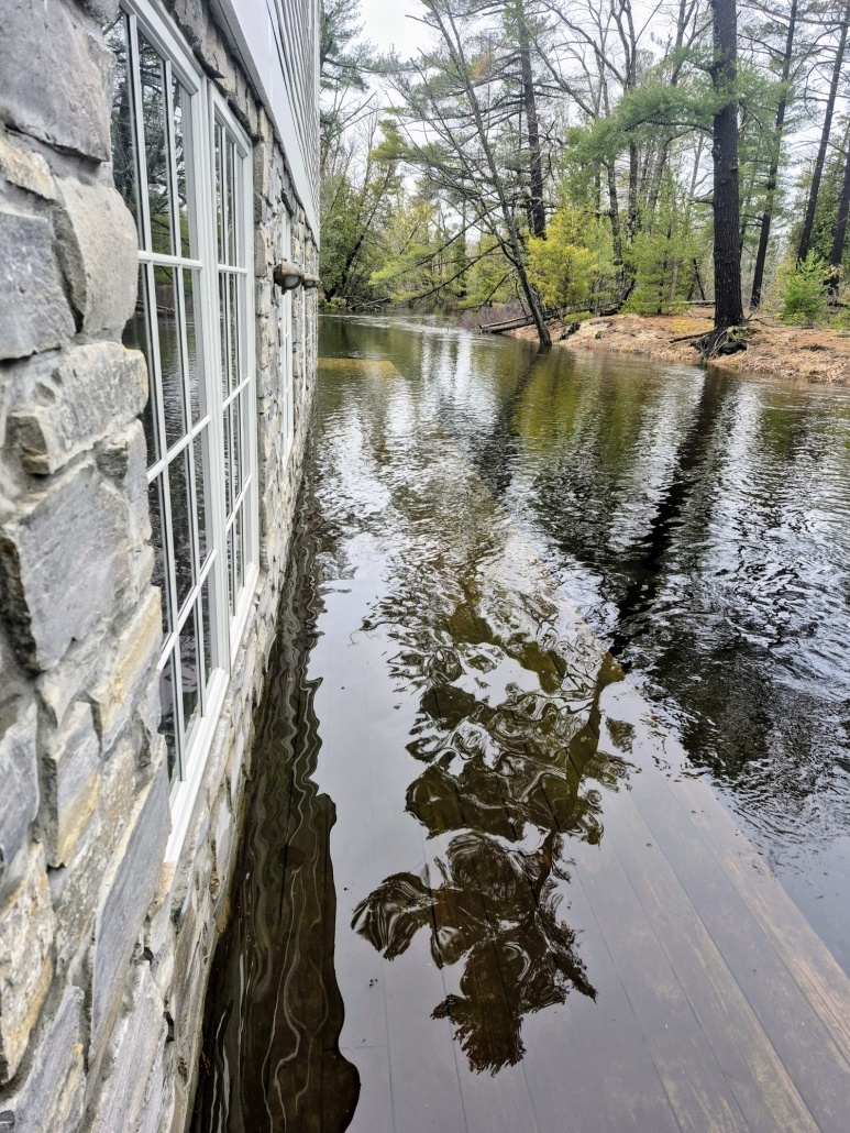
Photos of April flooding at The Mill on the Crystal River by Norm Wheeler
From staff reports
The good news is that the Crystal River is healthy. She winds like a lazy snake through wetlands protected by the Sleeping Bear Dunes National Lakeshore, so when excessive rain or snowmelt inundate her environment—as happened during record flooding in early April—the extra water has a place to go.
“When you look around the region and see how other watersheds faired, it’s obvious that we on the Crystal River have a lot going for us,” said Rob Karner, the Glen Lake Association’s watershed biologist. “That’s largely due to the wetlands that are not filled in but intact. Our well-functioning wetlands are what helped the Crystal River weather the storm.”
Karner, who has owned a riverside home for 50 years, contrasted the Crystal with Traverse City’s Boardman River, whose churned-up water looked tan brown and filled with sediment after the flooding triggered by severe rain and rapid snowmelt took out bridges and inundated basements. The city described the April deluge as a 500-year flooding event. By contrast, the Crystal looked clear within a couple days, Karner said.
“We don’t need cisterns and big aqueducts to [move] water. We have a natural system, so we don’t need huge infrastructure costs.”
 The other good news is that the removal of culverts in three locations under County Road 675 during the past five years has helped the river flow more freely and relieves pressure during high water events. The Crystal River restoration project was the result of a federal grant-funded collaboration between the Conservation Resource Alliance (CRA), the Leelanau County Road Commission and the Grand Traverse Band of Ottawa and Chippewa Indians. The goal of the project was to remove barriers the culverts posed to fish, wildlife, stream flow and human paddlers.
[The Sun published an online story on April 14 that unfairly and inaccurately cast the blame for flooding in the basement of The Mill last month on the removed culverts. Several readers wrote to us and criticized our oversimplified and hasty reporting.]
“Overall, the river responded well to unprecedented precipitation,” said Grand Traverse Band restoration specialist Brett Fessell. “Removing the culverts removed constriction of the river.”
In fact, the removed culverts might have prevented a nightmare scenario if backed-up water had created a “cut across” over an old dam where the river makes a turn to the southwest toward Glen Arbor.
“Having removed the culverts diminishes the likelihood of backwatering or flowing over the old sill,” said Fessell. “If it were to cut a channel there, the river would abandon the whole loop that goes to Glen Arbor.”
Multiple businesses, including Crystal River Outfitters and the River Club, rely on the proximity of the river flowing through town.
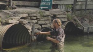
The last culverts
The submerged culverts beneath Overbrook Drive, downstream from The Mill, in mid-April.
The bad news is that two more culverts remain downstream of The Mill. Those culverts restrict water flow beneath Overbrook Drive, an entrance road to a community of 172 condominiums in South Beach, near The Homestead resort and the Leelanau School.
“Opening up [those culverts] to the greatest extent possible will improve that flow of water,” said Fessell. “If any trees or large wood gets lodged there, it can obstruct the river flow even more.”
Corey Smith, general manager at The Mill, told the Sun that he spent last winter on his kayak clearing those culverts downriver from the popular restaurant and café in the historic gristmill.
“Anytime the river level would rise, I took it as an indication to clear blockages at the culvert with a metal rake and sledgehammer,” he said. “Each time I did this, river flow would continue into Lake Michigan, lowering the high-water level at The Mill.”
Because Overbrook Drive is privately owned, applying federal grant money to close the road and remove the culverts—as was done on CR-675—would be more difficult.
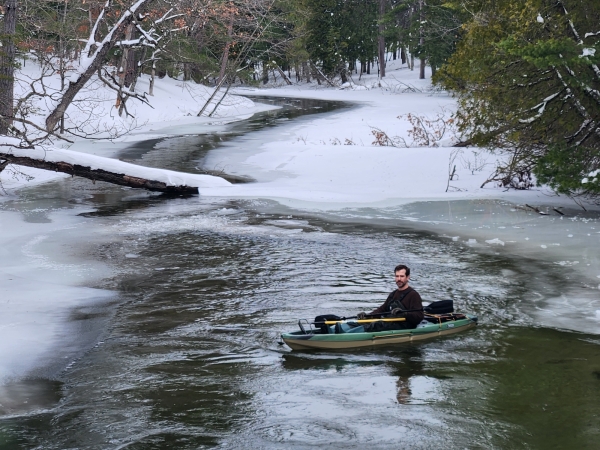
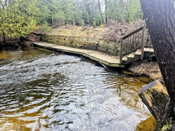
Corey Smith, The Mill’s general manager, patrolling the Crystal River downstream last winter.
Patrick Brown, the president of one of six different homeowners’ associations at South Beach who use that road to access their homes, told the Sun he feels bad about The Mill flooding, and he and his neighbors want to be good community partners. They are actively looking for partnerships to help fund the cost of removing or improving the Crystal River’s last remaining culverts.
“To replace that bridge would cost a lot of money, which we just couldn’t fund ourselves,” said Brown. “It’s a dilemma, no doubt about it.”
An upgrade of the Overbrook Drive crossing would benefit the river, Conservation Resource Alliance biologist DJ Shook told the Sun. Especially since last month’s flood.
“From a severity standpoint, [the Overbrook culverts] didn’t look like something that would raise to the priority level of the vast number of undersized culverts that are in watersheds that CRA works with.
“We’re all keenly aware of them now after this historic rain event.”
The Glen Lake Association (GLA) has the unenviable task of operating the Crystal River dam according to a binding court order that stipulates minimum flow requirements and establishes how water is shared between the lake and the river.
“We got an extraordinary amount of rainfall on the heels of an extraordinary amount of snow, which overloaded the system with water,” said GLA executive director Kate Gille.
Last month the GLA recorded the highest lake level and the highest river flow since the organization began tracking data in 2010. Peak river flow in the spring typically measures 95-100 cubic feet per second. But the GLA measured the river flowing at 159 cubic feet per second during the water deluge.
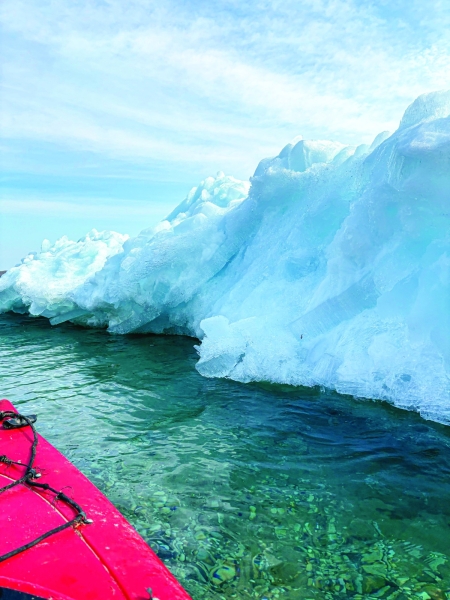
Ice piling up on Big Glen Lake last month. Photo by Ashley Siepker
“Unprecedented water like that changes how we educate our riparians,” said Gille. “People asked us why there was so much water. They wanted to know when the water will go down.”
Homeowners on the Glen Lakes reported and took photos of wind blowing ice mounds onto their windward shorelines, causing erosion.
“Nature will do what it does,” said Gille. “We recommend to riparians that they protect their shorelines using native plants to create a vegetative buffer.”
Climate change is new normal
Shook and Fessell both alluded to a “new normal”—and the tricky act of balancing the interests of the Glen Lakes, the river, wildlife and businesses along the shore—particularly during high water.
“The biggest challenge here is that everything happened at once,” said Fessell. “A different capacity to pass water through the system combined with an unprecedented flood event.
“We’re going to see a greater frequency or intensity of precipitation events. The bottom line is that infrastructure we’re currently using is outdated.”
That’s the other bad news. Scientists who study climate change in the Great Lakes region predict more frequent and more intense extreme weather events, including rainstorms.
Environmental journalist, and Benzie resident, Keith Schneider wrote a scathing column for Circle of Blue—an online news organization covering global water, food and energy—which posited that the myth of Northern Michigan as a safe haven from the ravages of climate change drowned in last month’s floods.
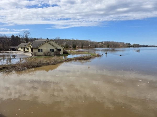
Traverse City’s Boardman Lake inundated with water last month. Photo courtesy Circle of Blue
Northern Michigan “rarely suffered the extreme climate disasters—wildfire, drought, wicked storms—that seriously damaged so many other parts of the United States,” wrote Schneider. “The perception of being a safe haven as large as Maryland where just 800,000 people lived had begun to attract migrants from climate-wrecked states in the South and West to settle in northern Michigan, especially in the counties [around] Traverse City, the region’s largest city.
“That perception ended on April 7. The light drizzle steadily built into a drenching rain that fell on forest soils saturated by the melting of the heaviest snowfall in years, including a storm in mid-March that dropped two feet of wet snow. The first flood emergency was declared for Cheboygan County, along Lake Huron, on April 10. Over the next week declarations were issued for 39 more counties, from Mackinaw City at the northernmost tip of Michigan’s lower peninsula to Ann Arbor in the state’s southern reaches.
“All that snowmelt and rain surged off the land into rushing rivers that crested two feet above previous record levels and caused the worst floods in the region’s recorded history. An earthen dam collapsed in Alcona County. A citizen brigade piled sandbags to hold the Homestead Dam in place in Benzie County, along Lake Michigan. Lakes and streams overflowed their banks, inundating hundreds of homes. Culverts washed out and water clawed huge gaps in important roadways, among them Beitner [Road] just south of Traverse City, and the iconic Tunnel of Trees on route M-119 along the Lake Michigan shoreline north of Harbor Springs.Top of Form
“Northern Michigan is not safe from extreme climate disasters. No region of the country or the world is.”