
Vintage Views and Early Michigan Travel
By Rebecca G Carlson
Sun contributor
The fifth story in our series on the history of Leelanau County resorts and getaways.
 On July 12–17, 1915, the third annual auto Pike Tour commenced. The route followed the Michigan lakeshore route of what everyone knows as U.S. 31, once called the West Michigan Pike in the early days of auto travel. Averaging “14” miles per hour, this auto group of an estimated “100” automobiles would cover “635 ½” miles in total beginning in the St. Joseph-Benton Harbor area, and ending the five-day tour in Manistee. Each day, depending on road quality, weather, and any unforeseen tire events, the average speed would be posted for participants in planning their trips. Averaging seven to almost nine hours of wind shield time each day, the median miles per hour ranged between 13 to 18 (Byron and Wilson Vintage Views Along the West Michigan Pike).
Remember, this was 1915. Siri was non-existent, and landmarks, not road signs, directed travelers. In these early days, paper maps may exist but were not necessarily reliable. After interviewing and gleaning as much knowledge as I could from Vintage Views book series authors, M. Christine Byron and her husband Thomas R. Wilson, I will never take travel for granted ever again.
An 1897 Traverse City Record Eagle (TCRE) article noted that, “The trip from Fouch to [Fountain Point Resort] consumes two hours through a stretch of beautiful scenery.” This referenced an overland trip from the train station at Fouch to Fountain Point, or roughly 13 miles. Let that sink in: two hours to travel 13 miles. I can travel from Traverse City to Grand Rapids (about 130 miles) in about two hours, depending on construction, traffic, and, I won’t lie, driving a ‘tad’ over the speed limit. Ten times the distance in the same amount of time. I will never take travel for granted ever again.
 Typical late 19th and early 20th century travel for the vacation traveler to the Leelanau Peninsula involved a steamship, a train, followed by horse and buggy to the final destination. From a 1905 Northern Michigan Transportation brochure (courtesy of Byron and Wilson Vintage Views Along the West Michigan Pike), a round-trip ticket from Chicago to Traverse City cost about $13 a person, which converts to about $475 in 2025. This covered a steamship berth, which included a private room, bed, and food. The round-trip ticket price also included travel by rail from Manistee to Traverse City. In 1905, the steamship Illinois left Chicago on Friday at 7 p.m., arriving to Manistee 16 hours later. Travelers would transfer to a train, the Northern Michigan Rail, and finish the trip to Traverse City, roughly about two additional hours. In total, 18 hours of steamship and train travel was involved, and then the horse and buggy leg would begin to the final destination.
The other, more sedate, option was to take the steamship all the way to Traverse City (TC) from Chicago which involved ten stops, arriving around 8 a.m. on Sunday. I think I could easily adapt to the leisurely travel of steamship and rail travel if it is ever resurrected. Not so sure about the teeth jarring horse and buggy part of the journey.
As car travel expanded and became more common and available to all, the train and steamship travel took a back seat. In an effort to encourage a return to the leisure travel of train and steamship, a TCRE article from 1927 promotes travel options that are “Not Dependent on the Highway.
This type of leisurely travel was slowly dying as many people could not afford to take too much time off from work. Thus, auto travel blossomed.
Writing a letter to friends coming to visit from the Chicago area in July 1919, Ernest Hemingway offered advice and encouragement for an upcoming camping trip to Horton Bay. In preparation, “Hemingway informed his friends [Howell Jenkins and Larry Barnett] that the best way to reach northern Michigan was the West Michigan Pike” (Byron and Wilson). Hemingway further added that the West Michigan Pike was a “‘pretty good’ road” and “they could make the drive in ‘less than three days.’” In 2025, mileage from Chicago to Horton Bay is about 357 miles, taking about six hours of drive time. Furthermore, Hemingway mentions that, “the route was listed in the Automobile Blue Books” which were “popular road guides” in early 20th century travel. Hemingway signed his letter “Hemmy,” further adding “all roads up here are good” (Byron and Wilson).
Providing a guide for the early auto traveler, routes between cities, turn-by-turn directions, garage addresses along the various routes, and a “What to take on the tour” comprehensive list, the Official Automobile Blue Books were a must for any early 20th century driver. The invention of businessman and auto enthusiast Howard Charles Gillette, these indispensable auto guides were published annually from 1901 until 1929. I felt fortunate to be able to handle a few of these guidebooks. Christine and Thomas were generous in sharing these priceless antique books with me during my interview in helping to explain distances and early Michigan driving routes. If anyone wanted to understand the nascent days of early 20th century driving, the “What to take on the tour” list offers a clear picture.
The thorough list contains many common-sense tools and items anyone would expect: tool kits, tire equipment, first aid kit, spark plugs, fuel equipment, jack, tire chains, spot light, travelers’ cheques, camp and lunch equipment, hand soap, and a compass. Makes perfect sense.
The items that I questioned were: “foot rest for gas throttle,” “headlight dimmer lenses,” “waste and cheese cloth,” “roll of chicken wire, 12 [inches] to pull out of sand,” “hydrometer,” and “motometer” (Bryon and Wilson). My grandfather, who spent his life working as a mechanical engineer for Buick, is probably rolling his eyes and shaking his head in whatever part of heaven he inhabits that his granddaughter has zero clue what any of these items are or how they are used.
I am proud that I learned to drive both automatic and manual drive cars. But that’s all I have. So, the driver now has the proper tools for the driving tour. What signage does this driver follow?
Signage. Never gave two thoughts to how early drivers in Michigan navigated around the state. After my mom, Megan, graduated from school, she began working for AAA creating Trip Tiks for customers. Trip Tiks were customized travel guides for any kind of road trip—anywhere in the U.S.
A user on Reddit posted, “I’ve been a member [of AAA] for 49 years now. It always amazed me how you could say you needed to drive to a town with a population of 4 people that no one had ever heard of, and they would just turn and go to the wall and start pulling pages. Then they’d stamp construction zones and detours on the map they were looking at upside down. And they were 100% correct with everything.” A satisfied customer.
Megan, the master map reader, made sure my brother and I knew how to read maps, a skill I have used throughout my life. In 2025, everyone grabs their phone and taps in the address of where they want to go—in seconds a route is revealed. Like magic. However, it was 1915, and the driving group in your car needed to make it to South Haven from Chicago. How did one navigate from Illinois to Michigan? There were no large green road signs with arrows, no mileage signs, no exit signs, nor are there the blue signs directing people to the local gas station or Wendy’s.
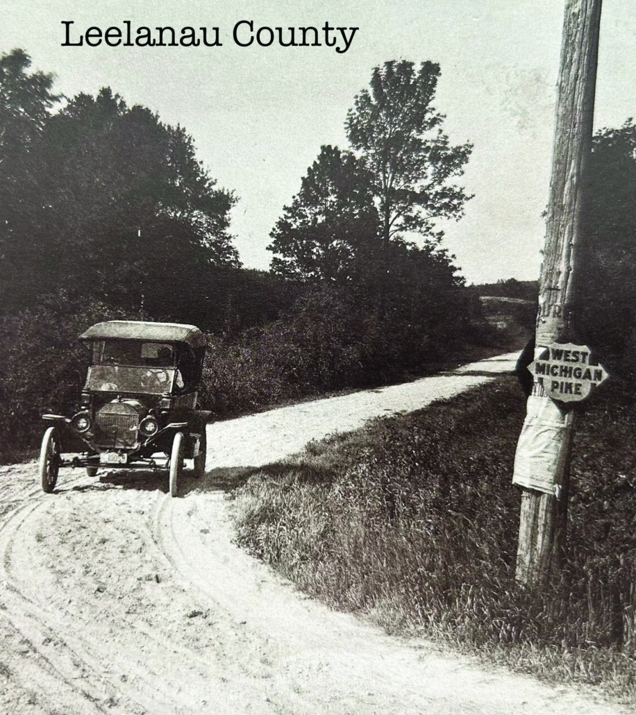
Enter local celebrity, David Henry Day, D.H. Day for us locals, to encourage vacation and road travel to the Leelanau Peninsula through signage.
“David H. Day of Glen Haven, President of the Western Michigan Development Bureau…was an avid good roads booster,” according to Byron and Wilson’s book. Furthermore, Day actively promoted and “participated in the West Michigan Pike Tours by hosting luncheons and touring parties at his farm out of Glen Haven” (Byron and Wilson). Day is responsible for marking parts of the route with signage of the West Michigan Pike in Leelanau County. There are wonderful pictures of D.H. Day included in Byron and Wilson’s Vintage Views Along the West Michigan Pike book. It was a brilliant move in that Day was not only promoting the use of signage for driving along the West Michigan Pike, which directly feeds into the Leelanau Peninsula, but encouraging the tourist to come and see the area. The Pike Tour opened the Leelanau Peninsula and Traverse City areas to the driving world of 1912 and on.
As difficult as it is to end this article, I dove deep into the early transportation topic of Michigan with the encouragement and support of Christine and Thomas. It is with deep gratitude for their dedication to collect vintage post cards that detail the story of Michigan travel as well as their extensive research on the topic. If anyone has not had the pleasure of reading and seeing, because they are visually beautiful, their series of Vintage View books, I recommend them all highly. I also promise not take travel for granted ever again.


2006 GREG JOLLIFFE 231-256-9291")

